Aviation

Flying the Piper Arrow II

Flying the Piper Arrow II

In March 2017, I moved to Toronto and with the change, left my airplane partnership in Vancouver. This meant I had to find another way to fly. I ended up choosing Durham Flight Centre for their convenience (located at Oshawa airport, CYOO) and the fact that they have quite a nice Arrow II available for rental. It’s a 1973 model with a GNS-430W IFR GPS, STEC-30 autopilot, digital HSI, three-blade prop and nice interior/exterior. I’ve been flying it for a couple months now and have accumulated a few main transition points.

The HARPEL Check

The HARPEL Check

Contrary to what most non-pilots think, a lot of flying is actually very mundane and uneventful. There is a saying among pilots that flying is 99% boredom punctuated by 1% moments of sheer terror, indicating that routine flying can quickly become exciting - but not in a good way. Something that’s always helped me stay on top of the airplane - maintaining good situational awareness and preparedness should an emergency occur - is the HARPEL check.

Lillooet, BC (CYLI)

Lillooet, BC (CYLI)

Yesterday, a buddy and I made it up to Lillooet (CYLI), which has an airport I intended to visit last summer but had to cancel multiple attempts due to thunderstorms. Yesterday being a crisp, clear January day made it a prime opportunity to see the airport.

We flew the leg to Lillooet via Hope and Lytton at 7500’, getting into YVR terminal airspace around Cloverdale. With the exception of some turbulence near Lytton, where several valleys converged, the flight was super smooth.

Low Pass Over Runway 26L at YVR

Low Pass Over Runway 26L at YVR

I did another low pass over YVR, this time over runway 26L with a friend who’s camera is significantly better than the Sony action camera I normally use.

Featured on Aviation News Journal Magazine

Featured on Aviation News Journal Magazine

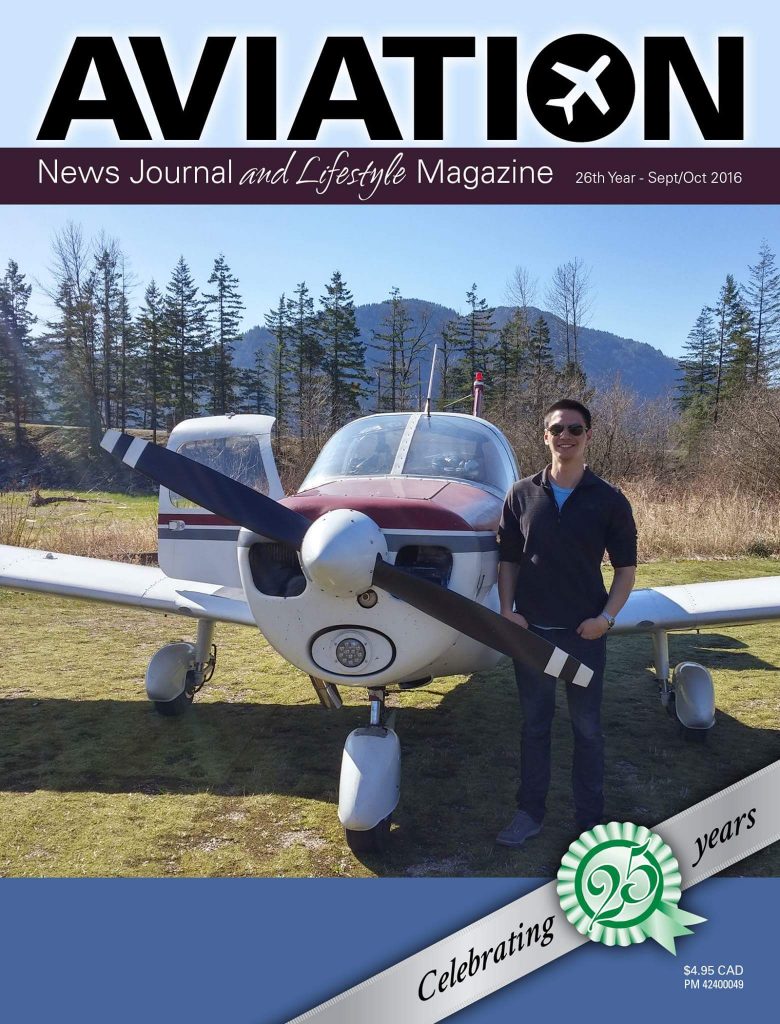
It was my great honour this September to be featured on the cover of Aviation News Journal Magazine. Accompanying the front page photo is a short bio of yours truly to accompany the cover photo, mostly describing how I got into aviation and hope to inspire others to do the same.

Toronto Trip – July 2016

Toronto Trip – July 2016

What does one do when on vacation in Toronto during a sunny July? Go flying of course!

I chose to fly out of Toronto City Airport (CYTZ) for a touch and go at Oshawa (CYOO) before returning for a few orbits around downtown. The weather was fantastic (albeit a bit hazy), and the air was very smooth once above a few hundred feet. We (instructor and I, I didn’t want to have to do a checkride just for a scenic flight) flew to and from Oshawa along the shoreline and passed over the Pickering Nuclear Generating Station. The flight was in a 1997 Cessna 172R - much nicer than the significantly older 172 models I’m used to flying.

Flight Planning

Flight Planning

Preparing for a flight is something every pilot does in his or her own particular way. We’re taught the basics in PPL ground school and demonstrate a prescribed method for the checkride, but it takes hours (and years even) of experience beyond the basic training for each pilot to enhance and refine their own methods.

With the many technologies available today, we no longer have to rely on measuring angles and distances on paper charts to plot routes. And with several useful tools available online and for free in most cases, we can plan routes and check weather faster and with better big-picture understanding than ever. My personal favourite is still the ForeFlight iPad app, which I find excellent for both flight planning and in-flight situational awareness. They now also have an online version of their tool that is very handy for planning routes from a computer and having it automatically synced to the app. For those without a ForeFlight subscription, SkyVector is an excellent free alternative that has complete coverage in the US and some basic maps for Canada. It will now even produce a nav log that you can print out and fill in along the flight. For visualizing both forecast and real-time weather, my current favourite tool is Windyty, which also has good Android and Apple apps. Of course, the standard Nav Canada weather website should be the primary source of weather information in Canada.

Tofino, BC (CYAZ)

Tofino, BC (CYAZ)

Tofino has been a destination I’d had in mind for some time before finally being able to make the trip. The airfield is an old military field with three large runways, located only a 10 minute walk from a gorgeous beach. It’s also known for intense fog in the mornings even during the summer, so it’s generally a less popular destination in the winter. That being said, I managed to get lucky the past long weekend and made it in for a great day on the beach and some awesome tacos from Tacofino (highly recommended!). Not many planes were flying on the outbound leg to Tofino in the morning, but we did run into some traffic nearer to the airfield. We also got the chance to watch some military paradrops over the airfield as we were approaching.

Oliver, BC (CAU3)

Oliver, BC (CAU3)

Yesterday marked the longest flight I’ve done to date at about 188 nautical miles (or 347 km). It was an excellent November day with just some SCT 125 clouds and smog/haze, so I chose to take the opportunity to push a bit further into the interior than my last flight to Princeton. My eventual goal is to fly to Castlegar (CYCG), so Oliver (CAU3) was a logical intermediate airport at about 76 nm from Castlegar (straight line distance).

Flight to Campbell River (CYBL)

Flight to Campbell River (CYBL)

This past Sunday I managed to take a windy, mid-November flight to Campbell River. For most of the first leg up the Sunshine coast we faced 25-30 knot headwinds from around 330°M but did manage to enjoy the same winds on the return leg. I took a bunch of photos on both legs, mostly of the cool cloud formations brought out by the two weather systems meeting in the area.